Coyote Two Moon 55k
Coyote Two Moon 55k
The 55K Is Back (Again)... And Better Than Ever-ish!
You asked for it.
So we made it.
Then we had it for the first time in 2025.
You loved it so it’s here to stay, because we’re never satisfied and, honestly, neither are you.
Introducing the 55K a reimagined, reworked, re-looped course that’s more beautiful, more badass, and just the right amount of ridiculous. This spicy little ultra will have you joining the chaos after the 100-mile and 100K runners are already deep in their own personal pain caves. (Cheer for them! Or just quietly pass them while pretending you’ve been running longer. We won’t tell.)
You’ll get to: Summit the legendary Topa Topa Bluffs (yes, it's as majestic as it sounds)
Trot through the magic of Rose Valley, complete with an actual waterfall and it might be flowing???
Climb Chief Peak…… Climbing Chief Peak is totally optional, but highly encouraged if your legs are still on speaking terms with you.
Seriously, what other race gives you the choice between:
The fast way around (speedy, efficient, no judgment)
The high road to the summit (slower, steeper, infinitely more epic)
If you’re a speedster chasing seconds, the bypass is your friend.
But if you’re here to earn the views, soak in the soul rewards, and maybe have a minor existential moment on a peak — then take the summit route. You won’t regret it…..Your quads might. You're welcome.:)
THE PARTY STARTS:
📍 Saturday, May 2nd, 2026
🕗 8:00 AM sharp Sleep in compared to the 100-milers. Flex on them. Then run your heart out So if you’re looking for a race that’s got big climbs, big views, a tiny bit of chaos, and zero regrets, this is it. Bring your snacks, your sass, and your trail legs the 55K is ready for you.
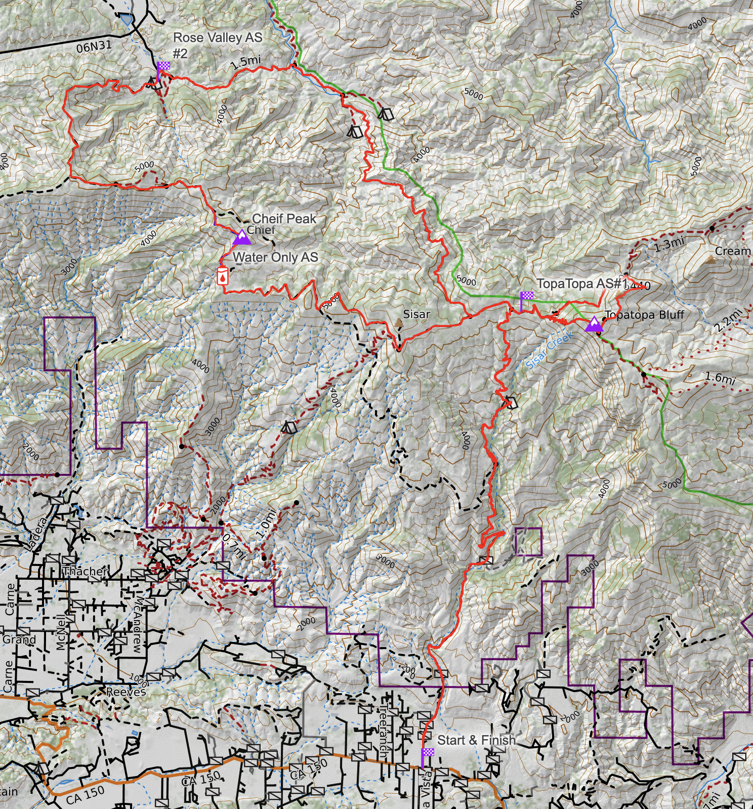
Mile 0.0 to Mile 7.09
Start Rock Tree Sky School Start at an Elevation of 1,574 ft. - Topa-Topa AS # One at 5,273 ft.
From the School run North on Sisar Rd passing several homes on your left and right. At .5 mi, you will come to an iron gate and leave the asphalt road to dirt fire road. Continue north on Sisar Canyon passing several stream crossings and switch backs. At mi 4.24 and at 2,768ft you will find a large iron yellow gate. Right after the gate, you will see a single-track trail called Red Reef on your right. Take Red Reef trail through White ledge campground mi 5.29 at 3,667ft. Continue climbing north to Forest Service Road FS 05NO8. You will arrive to intersection of FS05NO8 and Red Reef trail, this is Mi. 6.94 and at an Elevation of 5,111ft. Turn Right (East) towards the TopaTopa bluffs and you will find Aid station #1 at Mi. 7.09 at an Elevation of 5,273ft.
Topa-Topa AS # One at an Elevation of 5,273 - Topa-Topa AS # One at an Elevation of 5,273
Mile 7.09 to Mile 10.76
Fuel up and prepare for your first ascent of the TopaTopa’s. Leaving Aid station #1 head east towards the summit on the fire road. At mi 7.47 and at an Elevation of 5,412ft turn right you will leave the Fire road for the TopaTopa Bluff trail continue up the switchbacks not the direct fire line break. You will reach the summit at mi 8.2 mi and at an Elevation of 6,379 (get your 1st bracelet). From the summit, follow single-track ribbons down towards Old TopaTopa Bluff Road. Once on the Old TopaTopa Bluff Road turn left on the Old TopaTopa Bluff Road at mi 8.27 at an Elevation of 6,191ft. Continue Northeast on Old TopaTopa Bluff Road until you reach Red Reef trail intersection at mi 9.29 at an Elevation of 6,048. Follow Red Reef trail to Aid Station #1 at mi 10.60 at an Elevation of 5,273ft.
Topa-Topa AS# 1 at an Elevation of 5,273 ft. - Rose Valley camp ground AS # 2 and 3,416 ft.
Mile 10.76 to Mile 17.56
Head west on FS05NO8 towards Lion Canyon trail. At the intersection turn, right you will be at mi 11.41 at an Elevation of 5,135. Continue North West on the narrow single-track Lion Canyon trail, there are not any other trails intersecting Lion Canyon trail until you reach West Fork and East fork Lion campground. This intersection is at mi 15.1 at an Elevation of 3,412. From the Campground intersection, continue straight across the stream follow along the east side of the stream until you reach the intersection on Middle Lion trail, Rose-lion trail and Lion Canyon Trail. Turn Left on to “Rose-Lion Trail” this is at mi 15.70 and at an Elevation of 3,377. Shortly after the intersection you will cross the stream and continue west on Rose-Lion Trail towards Rose Valley campground. After winding through this canyon and a small climb, you will arrive at Aid Station #2 Rose Valley campground at mi 17.56 and at an Elevation of 3,416.
Rose Valley AS # Two at an Elevation of 3,416ft mi -TopaTopa Aid station # One at 5,271ft
Mile 17.56 to Mile 26.95
The climb is steep and approximately 2.44 mi and 1,597 ft. of vertical gain. As you make your way to the 3-way intersection of FS, 05N42.2 and FS-05NOB8 stay left (East) along the FS-05NOB8 Fire Road. As funky as a disco in a rainstorm, C2M throws you a curveball at mile 21.10. You’ve got a decision, my friend: keep running down the fire road to the unmanned aid station (where you might have to make small talk with some shrubs), or take a hard right and summit Chief Peak (don’t forget to snag your bracelet like you’re collecting Pokémon) to reach the same unmanned aid station at mile 22.68.
So, if you’re feeling spicy, the "up and over" option is just a cozy 0.90 miles with a nice little bonus of 431 feet of uphill followed by a dramatic 766-foot plunge into the abyss (okay, it’s not an abyss, but it's a drop).
The “around the Chief” route, on the other hand, is a casual 1.58 miles with 8 feet of elevation gain (don’t get too excited) and a modest 334-foot descent. And guess what? Both routes lead to the same unmanned aid station. It’s like a secret club where the only members are you and your water bottle. How cool is that?
At approximately mile 22.68 you will find a water only unmanned aid station. Shortly after the unmanned aid station at mile 24.39 you will come to the intersection of FS 05N08 and Sisar Canyon fire road, turn Left on to FS 05N08 going up towards Sisar Peak. Once you pass the access road to Sisar Peak continue on FS 05N08 all the way to TopaTopa Aid station # One at an Elevation of 5,271ft.
TopaTopa Aid station # One at an Elevation of 5,271ft Rock Tree Sky School finish 1,574 Ft
Mile 26.95 to Mile 33.89
Fill up and prepare for the long downhill to the finish. Leave the Aid station heading west on FS-05N08 after a short downhill you will turn Left on Trial 21W08 towards White Ledge campground at mi 28.58. Continue passed the campground until you reach Sisar Canyon Fire road at mile and you will find a large iron yellow gate go past the gate going downhill. Sisar Canyon Fire road this will be at mi 29.67 and at an Elevation of 3,291. Stay on Sisar Canyon Fire road to the finish at Rock Tree Sky School 33.89 mi


